Hiking the Greek Islands
In Greece, local islands are cleaning up their hiking trails, and there’s never been a better time to explore the islands on foot. Depending on what island and trail you choose, you’ll stumble upon ruins, coastal views, and endemic plants. Here are some of the best hikes in Greece:
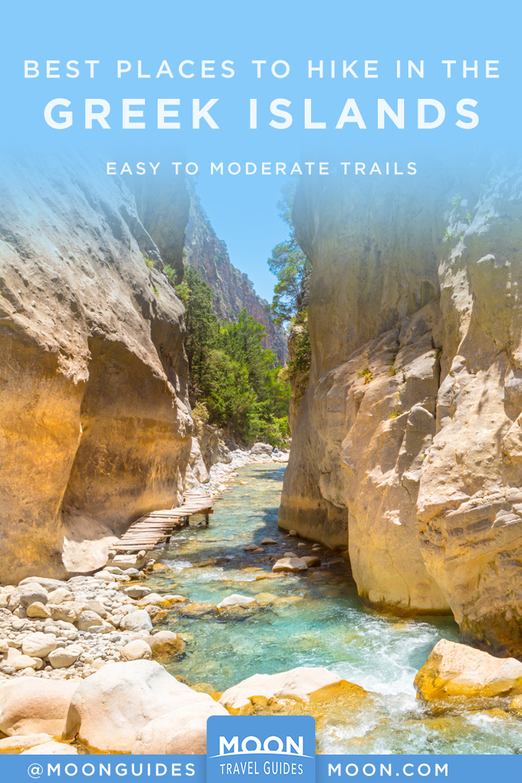
Samaria Gorge, Crete
16 km (10 mi) one-way
Walk through a wildflower-covered gorge that ends with a dip in the sea.
The stunning, 16-km (10-mi) long Samaria Gorge is one of the longest canyons in Europe, and a definite bucket-list item for any athletic visitor to Crete. Sheets of rock zoom up into the blue sky, and bubbling brooks cut through the rocky terrain. The gorge is partly forested, and it’s home to dozens of endemic plants and wildflowers that the Cretan goats like to nibble. The gorge ends at the sea, and you’ll be able to go for a dip after your hike.
Hiking the Gorge
Distance: 16 km (10 mi) one-way
Duration: 4-8 hours
Effort level: moderate
This hike takes you through the gorge itself. You’ll start the hike in the village of Xylóskalo just south of Omalos, following a steep, stony path before catching a glimpse of the Agios Nikolaos chapel. Say a quick prayer (you may need it for the next dozen kilometers), and continue through the abandoned village of Samaria, a geological feature known as the Sideroportes (Iron Gates) at the 11-km (6.8-mi) marker, and the final stretch to Ayia Rouméli (the exit of the gorge), where the turquoise Mediterranean laps at the beach. You can stop here to have a beer and dip your feet in the cool water. In Ayia Roumeli, Anendyk (www.anendyk.gr) ferries wait to take hikers to Sougia or Hora Sfakion (€8.50). From there, you can take a public bus (2 hours) or taxi (€75) back to Chania.
It’s best to start the hike in the early morning, as the park rangers don’t let anyone hike more than 2 km (1.25 mi) after 2pm, and you’ll need to be out of the gorge by sunset (camping overnight is strictly forbidden).
Alonnisos
This herb-scented island is basically a walker’s paradise. Start off with the small walk between the port and Palio Alonnisos; at the end of your hike you can reward yourself with a slice of cake from Hayati, a well-loved sweet shop, or glykopoleio.
Alonnisos has 14 surveyed, numbered, and signposted walks, which include both short walks to hidden beaches, and longer routes. Thanks to the effort to clean and organize these hikes, Alonnisos is a lot easier of an island to hike on your own than, say, Samothrace. Add to that the pure air, the beautiful vistas, and the stunning flora and fauna you’ll get to walk through, Alonnisos is truly a hiker’s paradise.
One of my favorite routes is from Gerakas to Tourkou Mnima:
Gerakas To Tourkou Mnima
Distance: 2.4 km (1.5 mi)
Duration: 30 minutes
Effort level: moderate
This short walk goes from Gerakas to the cove of Tourkou Mnima and takes you well off the beaten path. It’s not part of the numbered, “official” hikes, but it is marked with red dots so you won’t lose your way. From the snack bar on Gerakas, and before the little chapel of Agios Nikolaos, head east along the coast. At some points the vegetation will get quite thick, but it’s passable. About 1 km (.6 mi) in, the path ends, and you’ll see the pebbled bay of Tourkou Mnima; continue for another 200 meters (650 feet) till the end of the path and go for a dip in the water. Go back the way you came to return to Gerakas.
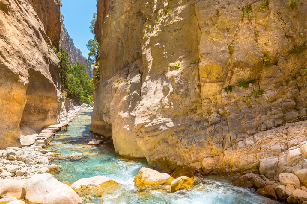
Corfu Trail, Corfu
220-km (137-mi) loop; can be hiked in sections
Hike through well-marked paths on this intense route that circles all of Corfu, passing through villages, across streams, and through forests.
The Corfu Trail is a 220-km (136-mi) long hike, marked by yellow signposts, that covers nearly all of the island, starting in Kavos and ending at Saint Spiridon beach. If you’re physically capable, it’s one of the best ways to revel in Corfu’s natural beauty and to get away from the hustle and bustle of the island’s touristic side.
Routes
From Paleokastritsa, serious hikers can follow the Corfu Trail to the villages of Lakones (4.6 km/2.85 mi, 1.5 hours, moderate) and Krini (7 km/4.3 mi, 2.5 hours, challenging), where you’ll find the ruins of the Byzantine fortress of Angelokastro and breathtaking views of Paleokastritsa. As you walk, you’ll pass through scented orange and lemon groves, and you’ll catch glimpses of the glittering blue sea. You can also drive; it’s a beautiful drive along the coast and up through the mountains. From Corfu Town, it’s 24 km (15 mi) northwest (35 minutes).
Guided Hikes
The folks at Corfu Trail (www.corfu-trail.com) have marked off dozens of trails around the island, and can organize week-long walking trips, including options on the Corfu Trail (pricing upon request only) for you. A good way to dip your toe is by hiking one of the routes around Mt. Pantokrator.
Mount Zas, Naxos
8-km (5-mi) loop
Scale the mountain where it’s said Zeus was born. The views will make you feel as though you’re floating above Naxos.
Standing tall at 1,004 meters (3,280 feet), Mount Zas is the highest mountain in the Cyclades. It’s also known as Mount Zeus, as it’s thought to be where Zeus was brought to be birthed in order to escape the wrath of his father. Zeus went on to become king of the Olympians. It’s a place with very strong energy! There are two popular routes for hiking Mount Zas. One is the well-marked, relatively easy 8-km (5-mi) loop from the church of Agia Marina: Drive from Filoti toward Apiranthos for 3.3 km (2 mi), and at the junction turn right to head to Danakos. Continue for 800 meters (2,600 feet), and Agia Marina is the second church on the right-hand side. The other is the 6-km (3.75-mi) loop from Arai Spring next to Filoti. The first half is well marked; beyond the cave you’ll just follow the beaten foot path. At some points, the walk can be steep, so make sure to bring sturdy shoes and plenty of water, and if you’re hiking in the summer, use sunscreen. The views alone are worth the hike up here—you’ll feel like you’re floating above Naxos. For more information, see www.naxostrek.com.
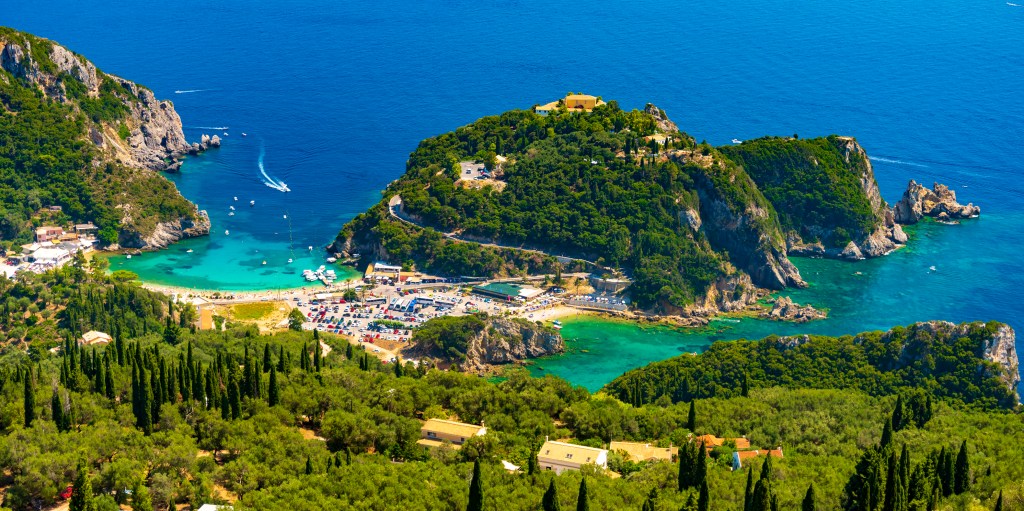
Fonias River, Samothrace
5 km (3 mi) one-way
Trek along a river to a large pool (perfect for a dip) and waterfall.
Distance: 5km (3 mi)
Duration: 45 minutes one way
Effort level: Easy
Fonias means “murderer” in Greek, and this river is so named because, outside of the docile summer months, serious flooding transforms the water into a gushing cascade. The river starts about 4.7 km (just under 3 mi) east of Loutra, near the Genovese Tower of Fonias, built in 1431. Still standing (relatively) tall at 12 meters (39 feet), it was built out of stone, plaster, and tiles, as part of a defensive line by the Gattilusi family. There’s no reason to go out of your way to see this, but if you’re hiking up Fonias River, it makes a nice pit stop (accessible by car). You can also drive from Loutra to start of the trailhead and park your car in front of the tower and then continue walking. The path meanders along the river heading into the interior of the island. The first 40 minutes (about 1.5 km/.9 mi) are well-marked, at which point you’ll come across a large rock pool perfect for a dip and a 12-meter (39-foot) waterfall called Paradeisos. The second pool is another two hours’ walk, but unfortunately, the paths to it and the other five waterfalls and pools are not marked. To find them, consult with Samothraki Travel before hiking farther. Each year, a lot of hikers get temporarily lost in the wilderness.
Folegandros’ Northwest Coast
Three separate trails (2-5.5 km/1.25-3.5 mi each) lead across the northwest coast of Folegandros, which is populated by only a few homes and farms. Depending on which trail you choose, you can access churches, a lighthouse, or, in the following hike, hidden beaches and coves:
Ano Meria To Ampeli Beach
Distance: 2 km (1.25 mi)
Duration: 30 minutes one-way
Effort level: moderate
The fastest hike from Ano Meria will take you west, first along a paved path to the Agios Panteleimonas church, before the road splits in two. Follow the southern hike down (it will suddenly steeply descend) to reach the beach of Ampeli, a small cove with turquoise waters and a strip of sand that’s accessible only on foot or by boat. Bring water and snacks!
Start planning your adventure today.
- Choose the right islands for you, with strategic itineraries for different timelines, budgets, and activities, whether you want to lounge on the best beaches, linger in ancient villages, explore the outdoors, or island-hop for a little taste of everything
- Focused coverage of Athens and 18 Greek islands, including Santorini, Mykonos, Karpathos, Corfu, Lefkada, and more
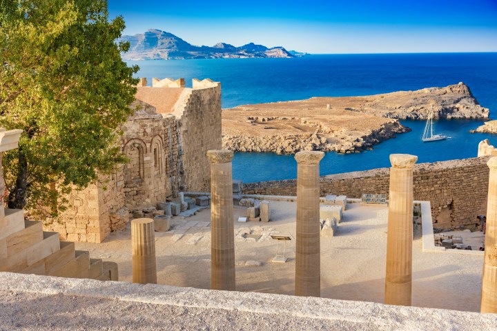
- Unique experiences and must-see highlights: Marvel at Oia’s picturesque blue and white architecture or take a boat to the birthplace of Apollo and Artemis. Soak in therapeutic hot springs, hike through lush forests to waterfalls in Samothrace, or hop aboard a boat and discover hidden coves and wild beaches. Learn about local folklore in Olympos, explore Athens’ contemporary galleries and ancient ruins, and savor authentic Greek cuisine, from roasted lamb and olives to dakos and fiery shots of ouzo
- Insight from Athens local Sarah Souli on how to experience Greece like an insider, support local businesses, and avoid over-tourism
- Full-color photos and detailed maps throughout
- Background information on the landscape, history, and cultural customs of Greece and each individual island
- In-depth coverage of: Athens, Santorini, Mykonos, Folegandros, Milos, Naxos, Anafi, Karpathos, Rhodes, Kalymnos, Samothrace, Ikaria, Lesvos, Alonnisos, Skyros, Corfu, Zakynthos, Lefkada, and Crete
With Moon’s practical tips and local know-how, you can experience the best of Athens and the Greek islands.
Exploring more of Europe? Check out Moon Prague, Vienna & Budapest or Moon Southern Italy.
About Moon Travel Guides: Moon was founded in 1973 to empower independent, active, and conscious travel. We prioritize local businesses, outdoor recreation, and traveling strategically and sustainably. Moon Travel Guides are written by local, expert authors with great stories to tell—and they can’t wait to share their favorite places with you.
For more inspiration, follow @moonguides on social media.
- Flexible, strategic itineraries: Choose the best home base for you, with itinerary options for 1-3 days in different regions and side trips that can be combined for a longer trip
- Authentic can’t-miss experiences: Discover the best beaches, ancient sites, hikes, nightlife, and more. Explore the well-preserved ruins of Delphi, kayak the Acheron River, or soak up the college-town vibe of Thessaloniki. Discover under-the-radar coastal getaways beloved by locals and snack on delicious mezze. Summit Mount Olympus, relax on unspoiled beaches, and tour Greece’s oldest stone-constructed villages
- Local insight on how to experience Greece like an insider, support local and sustainable businesses, and avoid crowds
- Helpful charts with travel times
- Full-color photos and detailed maps throughout
- Background information on Greece’s landscape, history, and mythology
Island-hopping on a longer trip? Check out Moon Greek Islands & Athens.
About Moon Travel Guides: Moon was founded in 1973 to empower independent, active, and conscious travel. We prioritize local businesses, outdoor recreation, and traveling strategically and sustainably. Moon Travel Guides are written by local, expert authors with great stories to tell—and they can’t wait to share their favorite places with you.
For more inspiration, follow @moonguides on social media.
By clicking ‘Sign Up,’ I acknowledge that I have read and agree to Hachette Book Group’s Privacy Policy and Terms of Use
What to read next:
Pin it for Later