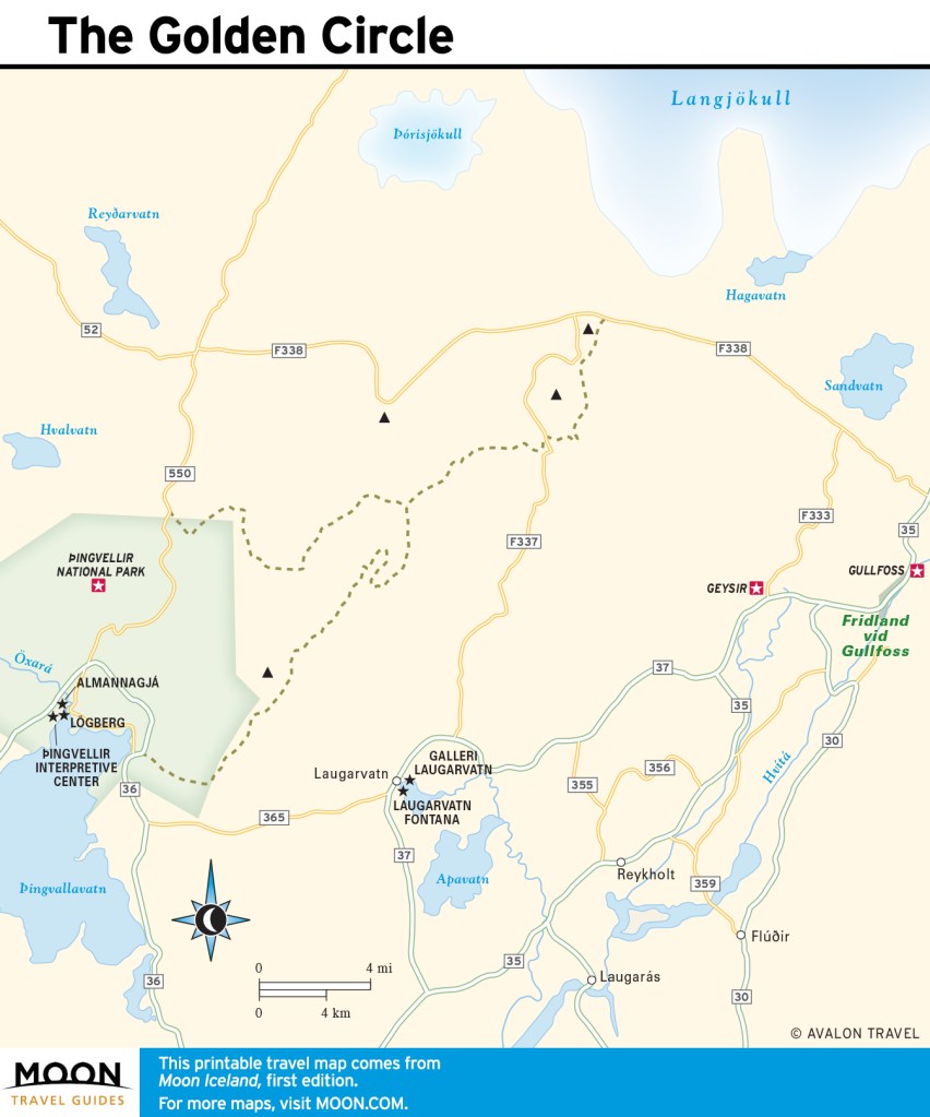
Visiting Þingvellir National Park in Iceland
Þingvellir (pronounced Thingvellir) National Park is one of the top sights along the Golden Circle. Located in South Iceland, the park is steeped in history and was designated as a World Heritage Site in 2004. In addition to historical sights, visitors can enjoy outdoor recreation activities including snorkeling, fishing, horseback riding, hiking, and camping.
The birth of Iceland as a nation happened at Þingvellir. Literally translating to “Parliament Plains,” Þingvellir was the site of Iceland’s first general assembly, which was said to have been established in the year 930, and was the meeting place of the Icelandic parliament until 1798. Many significant sights are at Þingvellir, including Almannagjá (All Man’s Gorge) and Lögberg (Law Rock). Þingvellir was established as a national park in 1930.
Visitors also come to the area for its geological significance, as it is the site of a rift valley that marks the crest of the Mid-Atlantic Ridge. It’s also home to Þingvallavatn, the largest natural lake on the island, which has a surface area of 84 sq km (32 sq mi).
Sights in Þingvellir National Park
Þingvellir Interpretive Center
tel. 354/482-2660; www.thingvellir.is; 9am-6pm daily May-Oct., 9am-5pm daily Nov.-Apr., adults 1,200ISK, children free
The Þingvellir Interpretive Center gives a great overview of the national park, its history, and its geological significance. Stop in to see the interactive display and then pick up hiking maps at the information center next door.
Almannagjá
footpath from the visitors center
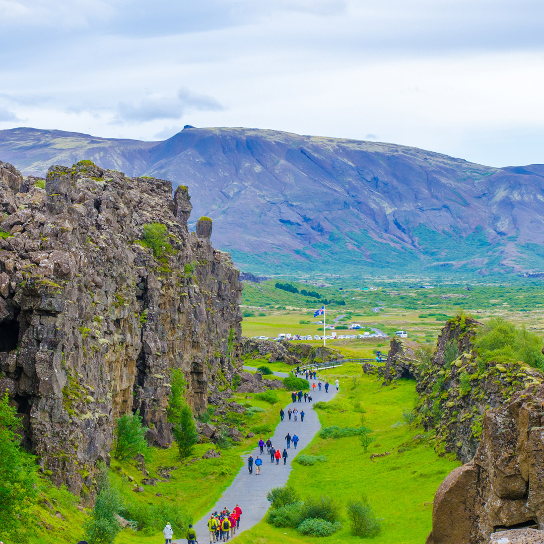
The park’s stony, moss-covered landscape is home to Almannagjá (All Man’s Gorge), which is the tallest cliff face in the national park and the original backdrop to Iceland’s first parliament. This rock structure is considered the edge of the North American plate, which visitors can view up close. It’s an impressive sight, so be sure you have your camera ready.
Lögberg
footpath from the visitors center
Lögberg (Law Rock) is where Icelandic democracy began. Iceland’s Commonwealth period ran 930-1262, and during that time, the Law Rock was the center of the Alþing (parliament). Members of the Alþing gave speeches and held events at the rock, including confirming the year’s calendar and issuing legal rulings. A man known as the “law speaker,” who was responsible for understanding all laws and was required to memorize them, read the procedural laws aloud every summer standing on the rock.
Öxará River
The Öxará (Ax) River flows over seemingly endless lava fields, emitting a haunting mist in the winter months. It’s serene and eerie until it reaches Öxaráfoss, where the water tumbles and roars over the cliffs. At the river’s edge are a church and farmhouse, the official summer residence of Iceland’s prime minister. The church, Þingvallakirkja (9am-5pm daily mid-May-early Sept., free), is a charming wood structure built in traditional Icelandic design that dates from 1859. Visitors can go inside, take photos, and sit on a pew and reflect. The interior features a wooden pulpit and bells from earlier churches. There’s a small cemetery behind the church where celebrated poets Einar Benediktsson and Jonasa Hallgrimsson are buried.
Silfra Fissure
off Route 36, about 60 km/37 mi from Reykjavík, inside Þingvellir National Park
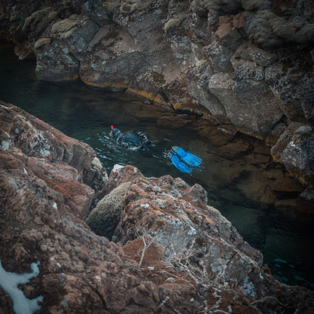
The Silfra fissure, filled with spring freshwater, is a popular site for diving and snorkeling tours. The crystal-clear depths reveals an underwater world with jagged canyon walls, plant life, and fish. The fissure is said to have opened in 1789 as a result of moving tectonic plates. It never freezes—freshwater constantly enters the fissure, so it never settles to freeze—and keeps a constant temperature of 2-3°C (35-37°F). To snorkel, Dive Iceland offers tours for those over age 16 and in good physical health.
Þingvallavatn Lake
Þingvallavatn is the largest natural lake in Iceland at 84 sq km (32 sq mi) and partially lies within Þingvellir National Park. The rift valley lake is where the North American and Eurasian tectonic plates meet, and visitors can dive or snorkel in the Silfra fissure.
Boats are not allowed on the lake, but fishing permits are sold at the information center, and they rent equipment too. Visitors have the chance to catch arctic char and brown trout. Be sure to obey the rules and pay for the permit. The fishing season at the lake runs May 1-September 30, and permits are about 8,000ISK.
Hiking
A natural place to roam, Þingvellir is lovely for the casual hiker. Acres of flat lava fields make hiking conditions easy, with plenty of walking paths, interesting rock formations, and rugged terrain to see. Be sure to watch for open rock fissures along the way; it’s easy to fall in. You can get information about trails and the surrounding area, as well as free detailed maps, at the visitors center.
Syðsta Súla
Distance: 13 km (8.1 mi) round-trip; Hiking Time: 7 hours; Information and Maps: www.south.is; Trailhead: Left turn on Route F-550
If you’re looking to scale some small mountains, check out Syðsta Súla, which reaches 1,085 m (3,560 ft) in the northern region of the park and is the park’s easiest peak to climb. The view from the top over the park is spectacular. Always be sure to check weather conditions before any hike, and make sure you have proper waterproof outer layers, sturdy footwear, a charged mobile phone, and drinking water. The ideal time to hike is the summer, as in the winter you will need proper snow gear.
Öxarárfoss
Distance: 4.5 km (2.7 mi) loop; Hiking Time: 1.5 hours; Information and Maps: www.south.is; Trailhead: Þingvellir National Park parking lot
Enjoy this short hike to the Öxarárfoss waterfall on a flat, even path. The trail is signposted throughout, and the scenery along the way is breathtaking, from views of Hengill (an active volcano) south of the park to the sweeping open landscape of jagged rocks covered with moss. The waterfall is quite beautiful, as it looks as if the water is escaping from the rocks, falling meters below.
Newsletter Signup
By clicking ‘Sign Up,’ I acknowledge that I have read and agree to Hachette Book Group’s Privacy Policy and Terms of Use
Snorkeling and Diving
Scuba diving or snorkeling in the naturally filtered pure water of Þingvallavatn lake is sublime. Surveying the underwater basalt walls, multicolored algae, and sloping sands is magical and unique—you’re able to snorkel or scuba in the Silfa fissure, the enormous crack between the Eurasian and North American continental plates. Don’t even think about going in without a dry suit, as the water temperature hovers around 3°C (37°F). Diving is possible year-round, but there are rules to obey, so don’t attempt to go without a guide.
Dive Iceland
Ásbúðartröð 17, Hafnarfjörður; tel. 354/699-3000; www.dive.is
Dive Iceland offers a Silfra diving tour for 33,490ISK. Travelers must be dry-suit certified to dive and must present their certification card. Snorkeling tours start at 20,490ISK.
Horseback Riding
Þingvellir is a popular spot for riding horses, with several trails that offer the chance to check out some of the more beautiful and geologically significant areas of the park.
Reykjavík Excursions
tel. 354/580-5400; www.re.is; 16,900ISK
Reykjavík Excursions offers a year-round horse-riding day tour in Þingvellir.
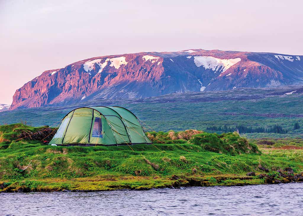
Camping
There are no hotels within Þingvellir National Park. However, there are accommodations in nearby Laugarvatn and Selfoss. If you would like to stay within the park limits, your only option is camping at one of Þingvellir’s four campgrounds, spread across the Leirar section of the park. All campsites have access to restrooms, electricity, and cooking facilities. Campers must bring their own tents.
Leirar Campground
GPS coordinates N 64.1648, W 21.5174; www.tjalda.is; June-Sept.; 1,800ISK pp
The Leirar section is a five-minute walk from the Þingvellir information center. The Leirar campground is divided into four campsites: Fagrabrekka, Syðri-Leirar, Hvannabrekka, and Nyrðri-Leirar.
Information and Services
The tourist information center (tel. 354/482-2660, 9am-4pm daily) is close to the car park. Be advised that there is a service fee of 200ISK to use the restrooms. There is also a small cafeteria to purchase snacks and drinks.
Getting There and Around
Þingvellir is 46 km (29 mi) northeast of Reykjavík. By car, it’s about a 45-minute drive; take Route 1 to Route 36, which will take you to the northern part of the park.
While there is no public transportation available to get to the park, a number of tours include a stop at Þingvellir. The park’s attractions are all within a walkable distance, so plan to be on foot.
Plan your trip:
Newsletter Signup
By clicking ‘Sign Up,’ I acknowledge that I have read and agree to Hachette Book Group’s Privacy Policy and Terms of Use
Build your Europe travel bucket list

Get inspired and get ready for adventure with the ultimate guide to Europe’s best trips!
Pin It for Later
