Coastal California Road Trip: The Sights of Big Sur
Big Sur is both the name of the town and of the coastal region along Highway 1 south of Carmel and north of San Simeon. Soaring cliffs dropping to sporadic white-sand beaches exemplify the Big Sur coastline made legendary in film and literature.

From north to south, the Pacific Ocean changes from slate gray to a gentler blue, and the endless crash of the breakers on the shore is a constant lullaby in Big Sur’s coastal towns. The region is explored via Highway 1, also called the Pacific Coast Highway, a road that hugs sheer cliffs and passes several state parks, resorts, and restaurants like Nepenthe, seemingly perched on the edge of the world.
The Big Sur Coast Highway, a 90-mile stretch of Highway 1, runs atop jagged cliffs and along rocky beaches, through dense redwood forest, over historic scenic bridges, and past several parks. Construction on this stretch of road was completed in the 1930s to connect Cambria to Carmel. You can start out at either end and spend a whole day winding your way along this road. There are plenty of wide turnouts on picturesque cliffs, which makes it easy to stop to admire the glittering ocean and stunning wooded cliffs.
Old Coast Road
Easily found on the left side of Highway 1, about 13 miles south of Carmel and just before Bixby Bridge, the Old Coast Road cuts high into the Coast Range of Big Sur. There are steep grades with areas of chunky quartz, slick muddy sections, tight turns through the redwoods, and narrow ledges. It is a little more than 10 miles to the end of the road and Andrew Molera State Park. The road is passable in dry weather, but in wet weather there are many flood-prone sections in the forest and steep loose grades. Most vehicles can handle the drive when it’s dry. The road has a handful of drainage pipes that are somewhat bumpy; like large speed bumps, low-clearance vehicles should traverse these with caution.
Bixby Bridge
You’ll probably recognize the Bixby Bridge when you come to it on Highway 1, about 18 miles south of Carmel. Among the world’s highest, Bixby Bridge is over 260 feet high and more than 700 feet long. The cement openspandrel arched bridge is one of the most photographed bridges in the nation, and it has been used in countless car commercials over the years. The bridge was built in the early 1930s as part of the massive New Deal government works project to complete Highway 1 and connect Northern California to the south along the coast. Today, you can pull out at either end of the bridge to take photos or just to view the attractive span and Bixby Creek flowing into the Pacific far below.

Point Sur Light Station
The Point Sur Light Station (Hwy. 1, 0.25 mile north of Point Sur Naval Facility, 831/625- 4419, tours 10 a.m. and 2 p.m. Sat.–Sun. Nov.–Mar., 10 a.m. and 2 p.m. Wed. and Sat.–Sun. Apr.–June and Sept.–Oct., 10 a.m. and 2 p.m. Wed. and Sat.–Sun., 10 a.m. Thurs. July–Aug., adults $10, children $5) keeps watch over ships navigating the rocky waters of Big Sur. First lit in 1889, this now fully automated light station still provides navigational assistance; keepers stopped living and working in the tiny stone-built compound in 1974.
To tour the light station, check the tour times online. Parking is off the west side of Highway 1 by the locked farm gate. Tour guides meet here to take a limited number of visitors 0.5 miles up the paved road to the light station. Once at the station, you’ll climb the stairs up to the light, explore the restored keepers homes and service buildings, and walk out to the cliff’s edge. Be sure to dress in layers; it can be sunny and hot or foggy and cold in winter or summer, and sometimes both on the same tour. Tours last three hours and require more than one mile of walking, with a bit of incline and more than 100 stairs. Take one of the moonlight tours (call for details) to learn about the haunted history of the light station buildings.
There is no access to the light station without a tour group. Tour schedules can vary from year to year and season to season; call ahead before showing up. For special assistance, call 831/667-0528 as far ahead as possible to make arrangements. No strollers, food, pets, or smoking are allowed on the property.
Newsletter Signup
By clicking ‘Sign Up,’ I acknowledge that I have read and agree to Hachette Book Group’s Privacy Policy and Terms of Use
Big Sur Spirit Garden
A favorite among local art lovers, the Big Sur Spirit Garden (47504 Hwy. 1, Loma Vista, 831/238-1056, daily 9 a.m.–6 p.m.) changes a little almost every day. The “garden” part includes a variety of plantlife, while the “spirit” part is modern and postmodern fair-trade art from nearby and as far away as India. The artwork tends toward brightly colored small sculptures done in exuberant naive style. The Spirit Garden offers educational programs, community celebrations, and musical events.
Big Sur Station
Pull in at Big Sur Station (Hwy. 1, south of Pfeiffer Big Sur State Park, 831/667-2315, daily 8 a.m.–4:30 p.m.) for maps and brochures to all the major parks and trails of Big Sur; there is also a small bookshop. Several of the smaller parks and beaches (Limekiln, Garrapata, and Sand Dollar) have no visitor services, so Big Sur Station serves visitors traveling to one of those less-visited spots. You can also get a backcountry permit here for the Ventana Wilderness.
Henry Miller Memorial Library
Henry Miller lived and wrote in Big Sur for 18 years. He began to cultivate this region as an artists colony in 1944, and his utopian 1957 novel Big Sur and the Oranges of Hieronymus Bosch put his Big Sur dream on the map. Today, the Henry Miller Memorial Library (Hwy. 1, 0.25 mile north of Deetjens, 831/667-2574, 11 a.m.–6 p.m. Wed.–Mon.) celebrates the life and work of Miller and his peers in this quirky community center, museum, coffee shop, and gathering place. You can flip through the collection of literature, be entertained by local performances, attend short film festivals, and more. The library is easy to find on Highway 1—look for the hand-painted sign and funky fence decorations.

McWay Falls (Moon Recommended)
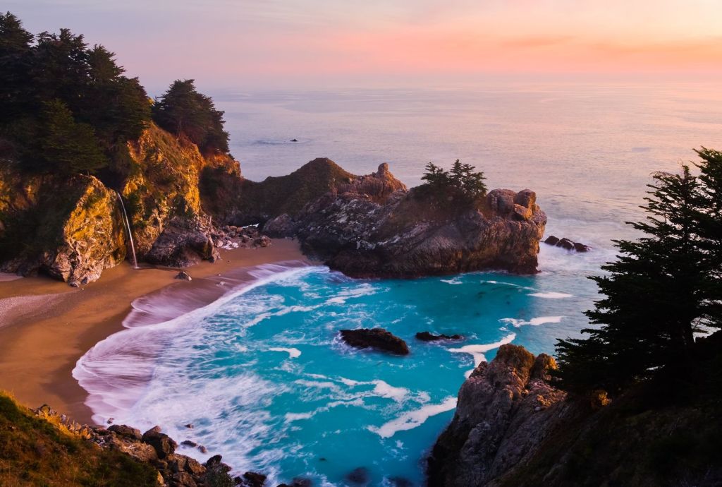
A popular photo op is breathtaking McWay Falls at Julia Pfeiffer Burns State Park (831/667-2315, daily sunrise–sunset, $10). A ribbonlike stream spews out of Anderson Canyon and falls some 200 feet to the pale beach below. The waterfall flows year-round, with heavier volume in winter and early spring. The hike is less than one mile and offers stunning views of the Big Sur coastline. The trail begins at Julia Pfeiffer Burns State Park, where the rolling hills drop dramatically to the sea and redwood forests protect the inland reaches. The trail ends at the ruins of the McWay Waterfall House, during the 1920s the home of Lathrop and Helen Hopper Brown. Today, a decaying foundation of the terrace is all that remains.
Esalen Institute
The Esalen Institute is a retreat from the world. People come from all over to this haven, sometimes called “the New Age Harvard,” for lengthy courses and classes, but massages and use of the bathhouse are available to nonguests.
Esalen isn’t a day spa. You must make an appointment for a massage (75 minutes, $150), which grants you access to the hot tubs for an hour before and an hour after your session. If you just want to sit in the bathhouse’s hot tubs, you have to stay up late—very late. Access to the Esalen tubs (831/667-3047, $20) is by reservation and is only possible 1–3 a.m.

The bathhouse, a motley collection of mineral-fed hot tubs with ocean views, is located down a rocky path on the edge of the cliffs overlooking the ocean. Once you’ve parked and been given directions, it’s up to you to find your way down to the cliffs. You can choose the Silent Side to sink into the water and contemplate the Pacific, or the Quiet Side to get to know your fellow bathers. Esalen’s bathhouse area is clothing-optional. You’ll have to find your own towel, grab a shower, and then wander out to find a hot tub. Be sure to go all the way outside, past the individual claw-foot tubs, to the glorious shallow cement tubs right out on the edge of the cliff.
Limekiln State Park
There is plenty of outdoor action and good camping at 717-acre Limekiln State Park (Hwy. 1, 52 miles south of Carmel, 831/667-2403, $8). Besides the historical lime kilns, there are deep-woods hiking trails and beach kayaking, fishing, and swimming. Squirrels, deer, foxes, and raccoons are often seen, attracted by the two creeks in the park. Mountain lions, bobcats, and ring-tailed cats are much more elusive but are known to roam the area. The day-use parking is limited to 12 spots, but you can park in the pullouts along Highway 1 just above the park. Day-use activities include picnicking, good shore fishing, and kayaking from the beach. Three hiking trails start just beyond the Redwood Campground. The Limekiln Trail (0.5 mile) is a hike to the cluster of historic lime kilns. The Falls Trail branches off the Limekiln Trail and leads to a 100-foot waterfall; be prepared to get your feet wet. The Hare Creek Trail is an easy hike through the majestic redwood forest alongside the rushing water.
In the thick redwoods and along a sheltered cove are campsites (summer by reservation, winter first-come, first-served, $35) that can accommodate tents and RVs up to 24 feet. The three sections of the campground are the Beach, Lower Creek, and Redwood Campgrounds.
Piedras Blancas
Six miles north of San Simeon is the Piedras Blancas Lighthouse (15950 Hwy. 1, 805/927-7361, tours 9:45 a.m. Tues., Thurs., and Sat., adults $10, children $5, under age 5 free), named after the white rock outcropping just off the point. It was completed in 1875, and the original tower was 110 feet tall. The beach around the lighthouse is a favorite resting spot for elephant seals. If you plan to take the tour, you may want to arrive early to ensure a spot, as space is limited. Tours meet at the old Piedras Blancas Motel, 1.5 miles north of the lighthouse.

The vista point with a parking lot just beyond the Piedras Lighthouse is a famous location to view elephant seals at the Northern Elephant Seal Rookery (Hwy. 1, 805/924-1628, daily sunrise–sunset, free). Home to roughly 15,000 giant northern elephant seals year-round, you can witness them molt, breed, give birth, and— their favorite pastime—rest. Much of the time the elephant seals are quite calm, but occasional sparring matches with deep guttural growling provide the best action. Be careful not to get too close to these creatures; remember that they are wild animals and can therefore be unpredictable and dangerous. A large parking area just off Highway 1 is alongside the beach, where you can view these impressive animals.
Newsletter Signup
By clicking ‘Sign Up,’ I acknowledge that I have read and agree to Hachette Book Group’s Privacy Policy and Terms of Use
Pin it for Later


