Chile’s Parque Nacional Laguna San Rafael
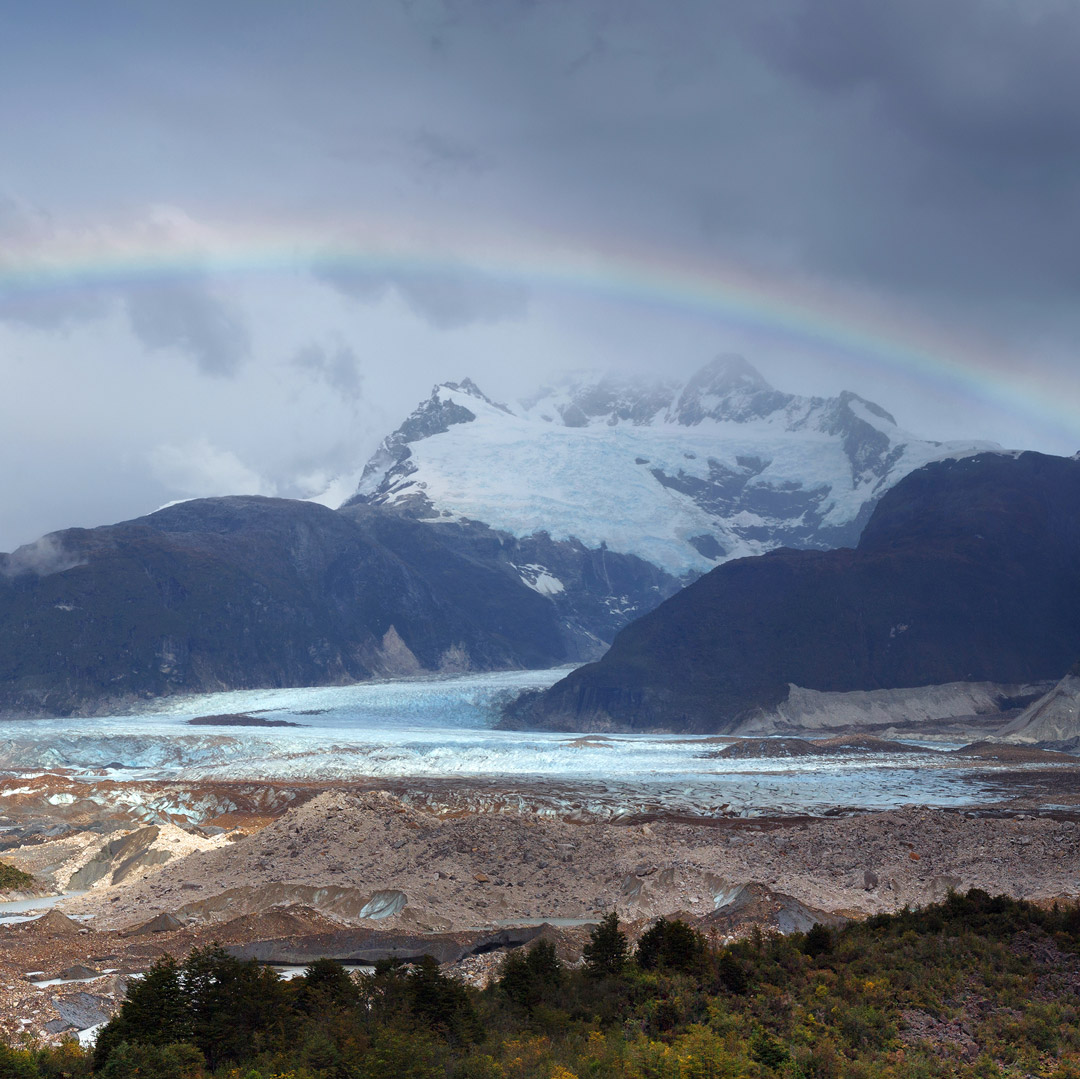
Flowing ice meets frigid sea at Laguna San Rafael. Frozen pinnacles tumble from the crackling face of Ventisquero San Rafael, a 60-meter-high glacier that descends from the Campo de Hielo Norte, to become bobbing icebergs. Misleadingly named, Laguna San Rafael is really an ocean inlet, though its salinity is low as the icebergs slowly thaw and the receding glacier—a palpable victim of global warming that may no longer reach the sea within a few years—discharges freshwater into it.
One of Chile’s largest national parks with 1.74 million hectares of rugged terrain, Laguna San Rafael is a UNESCO World Biosphere Reserve for its extraordinary scenery and environments. While remote from any settlement, it’s a popular summer excursion for Chileans and foreigners and is accessible year-round.
History of the Park
For a place so thinly populated and rarely visited, Laguna San Rafael has an intriguing history. Its first European visitor was Spaniard Bartolomé Díaz Gallardo, who crossed the low-lying Istmo de Ofqui (Isthmus of Ofqui) from the Golfo de Penas. Jesuit missionaries visited in 1766 and 1767, bestowing its present name, but the Spanish king soon expelled them from the continent.
British naval officer John Byron, grandfather of poet Lord Byron, once spent a winter marooned here. During the voyage of the Beagle, Charles Darwin made extensive observations, while Chilean naval officer Enrique Simpson delivered the first official report in 1871. In 1940, the government began a canal across the isthmus to simplify communications with the far south but soon gave up the project. In 1959 it declared the area a national park, but as late as the 1980s it entertained proposals to build a road for cargo transshipments.
Geography and Climate of Parque Nacional Laguna San Rafael
Laguna San Rafael is 225 kilometers southwest of Puerto Chacabuco via a series of narrow channels, but only 190 kilometers from Coyhaique as the air taxi flies. To the east rises the rugged Patagonian mainland; to the west lie the myriad islands of the Archipiélago de Chonos and the Península de Taitao.
Elevations range from sea level to 4,058-meter Monte San Valentín, the southern Andes’ highest peak. Sea-level temperatures are fairly mild, about 8°C, with upward of 2,500 millimeters of rainfall per year. At higher elevations, precipitation doubles, temperatures are colder, and the snowfall feeds 19 major glaciers that form the 300,000-hectare Campo de Hielo Norte. Pacific storms can darken the skies for weeks on end, but views are stunning when the overcast lifts.
Newsletter Signup
By clicking ‘Sign Up,’ I acknowledge that I have read and agree to Hachette Book Group’s Privacy Policy and Terms of Use
Flora and Fauna
In areas not covered by ice, up to about 700 meters elevation, mixed Valdivian forest grows so dense that, wrote Darwin, “our faces, hands and shin-bones all bore witness to the maltreatment we received, in attempting to penetrate their forbidding recesses.” The main trees are two species of the southern beech coigüe, the coniferous mañío macho (Podocarpus nubigena), tepu, and other species, with an understory of shrubs, ferns, mosses, and vines. Above 700 meters, there is almost equally dense forest of the southern beeches lenga and ñire, with occasional specimens of the coniferous Guaitecas cypress.
Most of the easily visible wildlife congregates around the shoreline, beginning with eye-catching seabirds, such as the flightless steamer duck and Magellanic penguin, black-browed and sooty albatrosses, and various gulls. Marine mammals include the southern elephant seal, southern sea lion, and southern sea otter.
Forest-dwelling animals are harder to see, but pudú and huemul graze the uplands, while foxes and pumas prowl for prey.
Sights and Recreation in Parque Nacional Laguna San Rafael
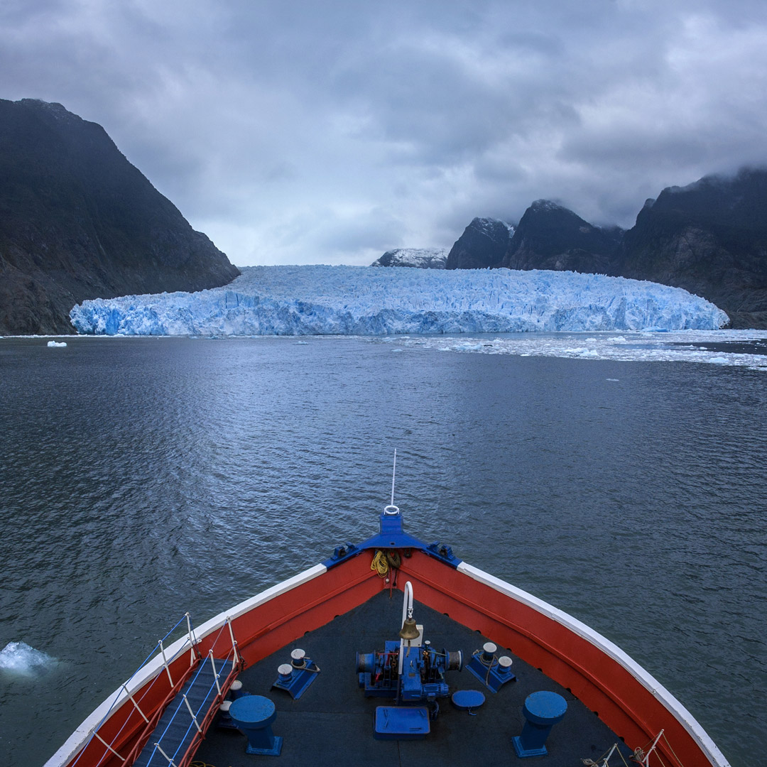
Calving off the face of Ventisquero San Rafael, indigo icebergs bob and drift in the waters of Laguna San Rafael, an oval body of water measuring six to nine kilometers in width and connected to the southern canals by the narrow Río Témpanos. The world’s lowest-latitude tidewater glacier, Ventisquero San Rafael may not be so much longer. In continuous retreat since 1960, it could become a casualty of global warming.
Few visitors actually set foot in the park, as most arrive by ferry or catamaran, transferring to inflatables to meander among the bergs and approach the glacier’s face. Those who manage to land can hike through seven kilometers of evergreen forest on the Sendero al Ventisquero to a glacial overlook.
Accommodations
At park headquarters, Conaf’s three-site Camping Laguna Caiquenes (US$8 pp for up to 6 campers) allows no campfires. Contact Conaf’s Coyhaique Patrimonio Silvestre office (Los Coihues s/n, tel. 067/221-2125) reservations. Dome tents are also available via package excursions with Turismo Río Exploradores (tel. 09/8259-4017).
No supplies except potable water are available. Bring everything from Coyhaique or Puerto Chacabuco. Ferries and catamarans feed their passengers; the catamarans usually have an open bar and chill the whiskey with ice chipped off passing bergs.
Information
Conaf’s administration and ranger station is on Laguna San Rafael’s northeastern shore. Anyone who sets foot in the park pays a US$11 admission fee, but boat people do not, as offshore waters fall under naval jurisdiction. According to Conaf statistics, which exclude maritime passengers, the park received only 4,728 visitors in 2015.
Transportation
There’s no cheap and easy way of reaching the park. Air travel usually means only an overflight, while sea travel can be relatively fast (in a catamaran) or slow (on a cruise ship) but still expensive. Catamarans spend only a couple of hours at the glacier, while cruise ships spend longer but are even more expensive. From the town of Puerto Río Tranquilo, on the north arm of Lago General Carrera, a new gravel road has reached Bahía Exploradores, only about 65 kilometers north of the glacier. The road’s completion has not eliminated the need for boat travel, only shortened it.
Air taxis rarely land at the 775-meter gravel airstrip, but Coyhaique-based charters can carry up to seven passengers on overflights for a price that may be negotiable. The current option is Transportes Aéreos San Rafael (18 de Septiembre 469, tel./fax 067/257-3083).
September to May, Cruceros Marítimos Skorpios (Augusto Leguía 118, Las Condes, Santiago, tel. 02/2231-1030) offers six-day, five-night cruises from Puerto Montt on the 130-passenger Skorpios II (from US$1,400 pp low season to US$3,300 pp mid-Dec.-Feb.). Rates depend on the season and on the cabin. Some voyages include a side trip to hot springs in the Quitralco fjord.
From Puerto Chacabuco, the catamaran Chaitén offers day trips (US$200-285 pp) that include full meals and an open bar. For details, contact Loberías del Sur (Pedro de Valdivia 0210, Providencia, tel. 02/2231-1902 in Santiago; José Miguel Carrera 50, tel. 067/235-1112 in Puerto Chacabuco).
It’s possible for hikers to reach the park by sea for day trips and for one- to three-night packages with dome-tent camping. It’s not cheap—about US$220 for the day trip and US$350 for overnighting, not counting transportation from Puerto Río Tranquilo to the end of the Río Exploradores valley road—but the price compares favorably to the catamaran and cruise-ship excursions. For details, contact English-speaking Ian Farmer at Turismo Río Exploradores (tel. 09/8259-4017).


Patagonia’s staggering landscapes, titanic glaciers, and rugged mountains evoke mystery and inspire self-discovery. Explore the ends of the earth with Moon Patagonia.
Newsletter Signup
By clicking ‘Sign Up,’ I acknowledge that I have read and agree to Hachette Book Group’s Privacy Policy and Terms of Use
Pin for Later
