Best West Maui Hiking Trails
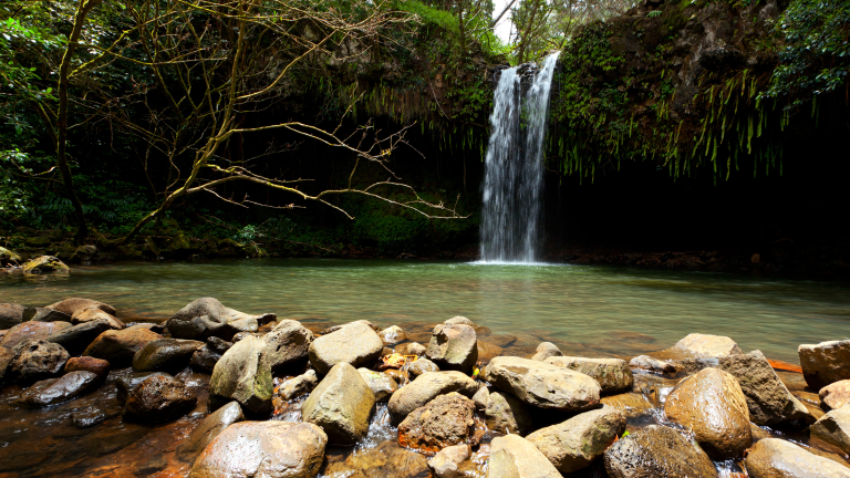
There aren’t nearly as many hiking trails on the West Side of the island as you might expect. Much of the access in West Maui is blocked by private land or lack of proper trails. Also, since much of West Maui sits in the lee of Mauna Kahalawai, there aren’t any accessible waterfalls, as there are in East Maui. Nevertheless, the hiking options in West Maui offer their own sort of beauty, from stunning coastal treks to grueling ridgeline hikes.
Hiking in Kapalua, Napili, and Honokowai
Kapalua Coastal Trail
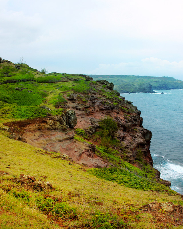
What makes the Kapalua Coastal Trail legendary are the various environments it passes through. If you begin at Kapalua Bay, the trail starts as a paved walkway paralleling the beach and weaves its way through ultra-luxurious residences. At the top of a short hill, the paved walkway reaches a junction by the Kapalua Bay Villas, where the path suddenly switches to dirt. Signs point to the continuation of the trail, and a spur trail leads straight out toward Hawea Point, a protected reserve that is home to the island’s largest colony of ‘ua‘u kani (wedge-tailed shearwaters). If you follow the grass trail to the left of the three-way junction, it connects with the trail to Namalu Bay—the rocky, Mediterranean cove hidden in the craggy recesses.

Continuing along the main Kapalua Coastal Trail leads over a short rocky section before emerging at a smooth boardwalk along Oneloa Bay. The boardwalk here was constructed as a means of protecting the sensitive dunes of Kapalua, and in the morning Oneloa is one of the most gloriously empty beaches you’ll find on Maui. At the end of the boardwalk, the trail leads up a flight of stairs and eventually connects with Lower Honoapi‘ilani Road. From here, take a left and follow the sidewalk as it connects with the trail running in front of the Ritz-Carlton before finishing at the water’s edge at D. T. Fleming Beach Park. For a side trip, hike out parallel to the golf course to Makalua-puna Point—otherwise known as Dragon’s Teeth.
Village Walking Trails
The village walking trails are the next most popular hikes in the Kapalua resort area. Weaving their way up the mountainside through the cool and forested uplands are the 1.25-mile (2-km) Cardio Loop or the 3.6-mile (5.8-km) Lake Loop, an uphill, butt-burning workout popular with local joggers. More than just a great morning workout, there are also sections of the trail that offer sweeping views looking out toward Moloka‘i and the area around Honolua Bay. To find the access point for the trails, park in the lot for the Kapalua Village Center (between Sansei Restaurant and the Kapalua Golf Academy) and follow a paved cart path winding its way down toward an underpass, where you will find the trailhead for both loops.
Mahana Ridge Trail
The Mahana Ridge Trail is the longest continuous trail in the Kapalua resort area and the best option for serious hikers. Though you can access the Mahana Ridge Trail from the village trails, a less confusing and more scenic trailhead is in the parking lot of D. T. Fleming Beach Park along the access road from the highway. The trailhead is a little hard to find, so look for the thin trail leading up the inland side of the road about 20 yards (18 m) back from the parking lot. This trail climbs up the ridge for nearly 6 miles (9.6 km), all the way to the Maunalei Arboretum, and is a proper hiking trail with narrow sections, moderate uphills, and sweeping views of the coast. It is an out-and-back trip, and maps are available online at www.kapalua.com.
Maunalei Arboretum Trail
To climb even farther up the mountainside, follow the Maunalei Arboretum Trail as it winds its way through a forest planted by the great D. T. Fleming. The manager of Honolua Ranch during the 1920s, Fleming forested the mountainside with numerous plant species from across the globe in an effort to preserve the watershed. Today, over 85 years after the arboretum was established, hikers can still climb the ridges of this historic upland and be immersed in a forest of wild banyan trees as well as coffee, guava, and bo trees. Trails in the arboretum range from short 0.5-mile (0.8-km) loops to a moderate 2.5-mile (4-km) round-trip that winds down Honolua Ridge. To reach the trails, you have to hike six miles (9.6 km) up the scenic Mahana Ridge Trail.
Newsletter Signup
By clicking ‘Sign Up,’ I acknowledge that I have read and agree to Hachette Book Group’s Privacy Policy and Terms of Use
Ohai Trail
The 1.2-mile (1.9-km) Ohai Trail awards hikers with panoramic vistas of the island’s North Shore. This area is often windy, and the way in which the wind drowns out all other sounds makes it a peaceful respite on the northern coast. The Ohai trailhead is 10 miles (16 km) past the entrance to Kapalua, by mile marker 41, between the Nakalele Blowhole and Olivine Pools. Along the moderate, winding trail are a few placards with information on the island’s native coastal plants. This is also a great perch to watch for tropical seabirds soaring on the afternoon breeze. There isn’t any readily available water on this stretch of coast, so be sure to pack a water bottle with you. There is sometimes a vendor selling drinks in front of Nakalele Blowhole, or a food truck (Mon.-Sat.) parked by Kahakuloa.
Hiking South of Lahaina
Lahaina Pali Trail
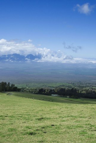
Hot, dry, and with incomparable views, the Lahaina Pali Trail is a walk back in time to days when reaching Lahaina wasn’t quite so easy. This 5-mile (8-km), three-hour (one-way) hike is the most strenuous trek in West Maui, as the zigzagging trail climbs 1,600 vertical feet (490 m) before reaching a crest by the Kaheawa Wind Farm. While torturous on both your legs and your thirst, the reward for the uphill slog is panoramic views over the central valley and dozens of humpback whales off the coast during winter.
Tracing its way over a part of the island that receives less than 10 inches (25 cm) of rainfall annually, this trail was originally constructed about 400 years ago during the reign of Pi‘ilani, who envisioned a footpath wrapping around the island. When a dirt road was constructed along the coast in 1911, the trail fell into disrepair. Nevertheless, hikers still encounter evidence of ancient activity, such as stone shelters and rock walls. It’s surreal to imagine that only 100 years ago this was the preferred route to reach Lahaina. To get the most out of this hike, pick up the hiking guide that the Na Ala Hele trail system has published, titled Tales from the Trail. It provides an interactive historical tour aligned with markers along the trail. Copies are available at the Department of Land and Natural Resources building in Wailuku (54 High St.), or, if you have a smartphone, download it as a PDF from mauiguidebook.com.
The downside of this trail is that since it’s a one-way hike, it can take some logistical planning. The Ukumehame trailhead on the Lahaina side is at mile marker 10.5, about 0.5 mile (0.8 km) past the tunnel in a small dirt parking lot on the inland side of the highway. If you depart from the Ukumehame trailhead, the path ascends moderately and offers pristine views of the coral reefs below. After the trail levels out at 1,600 feet (490 m), when you reach the crest by the wind farm, it descends steeply and sharply to the opposite trailhead between Ma‘alaea and the junction of Honoapi‘ilani Highway (Hwy. 30) and North Kihei Road. Your four options for the return route are to leave a car at the opposite trailhead, hike back the way you came, hitchhike back to the original trailhead, or turn back the way you came once you reach the wind farm (which is the shortest and most practical option).
If you plan on only hiking half the trail, setting out from the Ma‘alaea trailhead offers better views of the valley and Kealia Pond, whereas departing from the Ukumehame trailhead offers better views of the coast and whale-watching opportunities. For the intrepid and those equipped with headlamps, the Ukumehame side is the best sunset perch on the West Side. Since there is absolutely no shade on this hike and it can get brutally hot, it’s imperative to avoid the middle of the day and to pack more water than you would normally need. You’ll be passing over rocky, rugged terrain, so wear closed-toe shoes.

What to Read Next…


Explore more warm weather destinations


Pin it for later
